ABOUT
> history
>notes
>photo trail
> who we are
> our values
> terms of use
|
 |
Life On the T&T–Photo Trail (circa 1920-1930)
Click on the pictures to see a larger view.
For a modern expedition along the road bed see:
"20
Mule Team" Modern Expedition
Series below begins at Ludlow CA and terminates at Beatty NV.
|
|
|
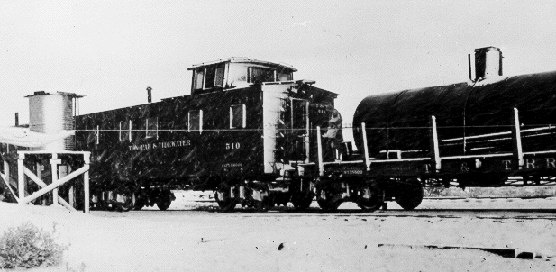
Ludlow — 1929
The T&T originated at Ludlow on the Santa Fe
|
|

Harry, circa 20 months; Already a big shot—that
means spoiled & bratty. |
|
|
|
Crucero > back
to top
Banks of Mojave & Union Pacific crossing.In later years, this is
where the trains turned around using a "Wye". |
|
|
|
|
|
Rasor > back
to top
Banks of Mojave and favorite parking spot with Mesquite
Rasor is accessible by car and is in the Mesquite country in the
heart of the Mojave Desert. But these trees of the desert have fallen
on hard times in this region. In the late spring of 1938, the Union Pacific
and the T&T suffered a "100 year" flood from the Mojave.
To prevent future repeats, the UP diverted the course of the Mojave into
Cronese valley to the West. One result was a lowering of the water table
that put the Rasor region into a permanent drought at the same time it
brought new life to Cronese. When this picture was taken, the water table
was some 6-8 feet below the surface. Today it is two or three times that.
Two large cottonwood trees commanded the landscape along with a 30 foot
high 30,000 gallon water tank. Steam engines refilling here could make
it all the way to Death Valley Junction.
One reason I loved Rasor is that after filling up, the steam
engines would blow out their pipes and cause a miniature
rain storm just to the left of the picture-artificial rain all of three times a week. Other reasons
were the shade under these big cottonwoods and plentiful
water. Rasor is a sandy place and one can get stuck in a
conventional car, a 4x4 is safer, as it is a long walk out.
Rasor supported a section crew and track walker full time
and the Outfit (see bio) occasionally. The track walker's job was to
check every railroad tie for loose spikes. He got around
on a hand-and-foot powered three-wheeled track walker, or
velocipede. Pablo Martinez was the track walker at the time
of the flood in 1938. His daughter Cholie and a friend rode
some 50 miles each way to school in Yermo. Her friend went
on to Barstow, an extra 10 miles each way—he was in
high school. Such daily treks were not exceptional for desert
folks.
The most beautiful time to visit Rasor is around Easter.
If you hit a lucky year, wild flowers will be in bloom. Purple
verbenas bloom everywhere in a wet year. Desert lilies too.
Desert lilies flower like lilies but they grow from bulbs.
Tall and stately, they were in great demand for the rare
bouquet hunter. A wet year usually meant an inch or so of
rain in February, perhaps more in March with warm (blooming)
weather arriving in April. |
|

Harry Sr. in Foreground
Under a
Cottonwood at Rasor |
|
|
|
Soda Lake > back
to top
Banks of Mojave, remote in early days.
No early photos are available. A spring flow here and the Mojave could
flood the salty marsh in the early days—it is now diverted westward
into the Cronese valleys to the West. Commercial activity has taken root
here in the form of a vacation or retreat spa. Look for the ZZYZX billboard
on I-15 a few miles South of Baker.
|
|
No Picture |
|
|
|
Baker & Dad Fairbanks > back
to top
Banks of Mojave and crossing for US Highway 91 (Interstate 15 today)
and the T&T
Baker supported a section crew; we parked there a number
of times. It is dim, but a railroad warning sign appears
in the right foreground of the image. Two hand powered gas
pumps are visible. The images that resemble modern gas dispensers
were actually oil dispensers--many cars of that vintage used a quart or more of oil every 500 miles or so. A row of sleeping rooms appear to the
rear of the awning. The figure in the center of the picture
may have been Dad Fairbanks himself.
Dad Fairbanks always tried to take good care of his customers.
They usually needed it. In the 1920's, Los Angeles was connected
to Salt Lake City by rail and a two lane country road. One
pass by a grader and an oil truck produced Highway 91 as
you see it. In the view above, the pavement can be clearly
seen in the foreground. The highway was moved and improved
in the early 1930's but didn't become four lane until after
mid century as part of the national Interstate highway program. Dad
Fairbanks was well known and his family became related to
the Brown and Lowe families of Shoshone. Some of their descendants
still live in the Baker area. In the right background a row
of rooms can be seen. They comprised the first motel in Baker.
The Brown family still operated a business in Baker the last
time I was through. Baker looks very different today of course. |
|

"Big Blue" Service Station, looking Northwest
from the West side of the T&T — circa 1928
Today I-15 runs just southeast. No sign of Big Blue can be found anymore. |
|
|
|
Silver Lake > back
to top
Mojave River terminus, playa lake
Silver Lake is about 10 miles North of Baker. This was a
freak snow storm, a once in a decade event. Sliver Lake was
also the lowest elevation along the T&T, only about 900
feet above sea level. Death Valley proper, in its Southern
extremities some 50 miles to the North, lies well below sea
level. Silver Lake is a playa lake with no outlet, at least
not since the last ice age. It is usually dry but the flood
of 1938 filled it to several feet. Motor boat races were
held—talk about excitement! Silt and clay make up its
dry surface. Whirl winds, AKA "dust devils" stir
up fine dust funnels that disperse high in the air.
The lake bed sported an emergency landing strip with minimal
lights on the airway from Los Angeles to Salt Lake City.
Near the beginning of World War II, a B17 on a training mission
got lost one night but managed to land at Silver lake. More
excitement. The crew was just a bunch of young kids. But
they knew how to fly and radio for help. Thanks to "Fog",
the radioman manning the runway, they found their way to
safety. We were living in Death Valley Junction that very
night and heard the airplane fly North and a little while
later fly back South. We heard the full story the next morning
and then drove down to inspect the track the plane left.
On the desert, you find entertainment where you can find
it.
Silver Lake is also where Jim Francis died in a car wreck
in later years. Jim owned and operated the general store
and Snake room in Tecopa. See Tecopa for more about the Snake
room. |
|

Harry's first snow.
Mother Nona holding him on the back deck of the caboose.
|
|
|
|
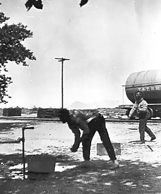
Riggs > back
to top
In the wilderness / horn silver (AgCl) mining prospects
near by.
Riggs siding was about 8-10 miles North of Silver Lake.
A section crew was also stationed here. The "desert
pavement" you see here was only a few feet above bed
rock. That meant no well water. A cistern was provided for
these situations and once a month or so the T&T would
send a water car with a train to replenish the cisterns for
crews at Evelyn, Sperry, and Riggs.
The T&T roadbed was built by muleskinners and some of
their worn out scrapers and equipment was abandoned here.
One of my earliest memories was of my father wringing out
the clothes after rinsing with his huge hands. Clotheslines
were temporary affairs. No modern conveniences here. Check
that. There was one—a telephone. A crank-by-hand party
line that required big dry cell batteries to operate. So
how did we have a mobile phone before the day of THE mobile
phone? Well, my father had this big safety belt and a pair
of lineman’s spikes. He used this equipment to climb
up a telephone pole and hook up the phone wire. Yes, WIRE.
Just one. (The other wire from ythe phone was hooked to one of the railroad
rails.) That same wire also provided for the Western Union
Telegraph connection—168 miles of a single wire phone
system. The wire was steel, another innovation of the times.
It was zinc coated according to folklore and verified as
such by Allen Miller of the research laboratory at Alta.
The telegraph operator in Silver Lake was our connection
to the rest of the world. Call him up, he would call your
party on the Bell system, and tap you in.
Ice was delivered to our doorstep by trains that made special
stops when you needed it. Mail was also a regular event.
I remember Blackie the conductor, sticking his arm out the
door as the train whizzed past. He would put his hand through
a reed hoop shaped like a "9" with this clothespin-type fastener on it to hold our mail. He replaced what we
sent with any we received and threw the hoop back to us—100
yards down the line. He never missed. Blackie also delivered
spuds and other foodstuff if necessary. Usually though, we
would drive to town to shop, which could be 50-100 or miles
away—in a Star coupe at first, then a Model A Ford.
If you look closely at the picture above you might realize
that there are no ashes under the water-heating tub. But
that is consistent with just having moved here after being
gone for a good spell. One or two wash days and we would
be off to the next washout or weakening bridge—to return
maybe years later. Camera? A Kodak pin hole box camera. Yep,
no lens. It was among my mother’s effects when she
passed on six and a half years after this picture was taken.
In
the left background you can see the Avawatz range—I
surveyed there in my younger years. The Spanish Trail used
by pioneers to settle Southern California passes through
the gap between the Avawatz and the low hills in the right
background. The Spanish trail was used some 50-60 years before
this photo. My pioneer great great grandmother, Anne Johnson, according to one version of family lore,
took the Spanish trail in about 1865 on her way from Utah,
and the played-out mining camps of Nevada, to homestead in
Chatsworth, California. She established a lineage that led
to me four generations later. |
|

This was home, folks. |
|
|
|
Val Jean > back
to top
In deepest wilderness.
We parked here just
once in my memory. No section crew, no water, only a siding.
One of the loneliest spots on earth. There was no road, but
our Model A Ford, a fore runner of the Jeep in where it could
go, could manage rough country in ways no modern car can.
In 1942, when I accompanied my father while taking an inventory of the rails, we stopped here for lunch. I looked around and along with a long-lost childhood toy, I found a bird's nest, complete with two sparrow chicks with their beaks opened wide for lunch. No telling how long they had been waiting--they were completely mummyfied by the searing heat and dry air. |
|
No Picture |
|
|
|
Dumont > back
to top
In deepest wilderness / sand dunes. Accessible as a side
trip off state route 127 in the Southern reaches of Death
Valley. |
|
No Picture
|
|
|
|
Sperry > back
to top
Sperry Wash, bank to bank across the Amargosa.
This view shows the bridge gang at work on one of the many
bridges crossing the Amargosa. My father is in the foreground
with a crew of four or five in the background. The white
grade in the background is no illusion. Much of the T&T
road bed in Sperry wash was "reinforced" by tailings
from the Borax mill in Death Valley Junction. The Spanish
Trail into Southern California crossed the T&T some
distance South of this bridge where the Road climbed out
of the wash onto the tableland. The Trail ruts were barely
discernible the last time I visited, 1942.
Sperry Wash nearly stopped the T&T from ever existing.
The original construction budget of $3,000,000 was exhausted
just North of this crossing, sccording to family lore. The Borax company dug deep and
finished the job, but the line ended in the black only four
times during its thirty-five years of service. The flood of '38
led to an operating loss of $30,000. Operations ceased in
1940. The line was dismantled in '42 and sent to Egypt as
part of the war effort. Some of the non functional equipment
was scrapped.
The pay scale was excellent for the time and place. Laborers
earned three dollars a day. But it was backbreaking hand
work in often disagreeable weather. It took some ingenuity
to handle heavy timbers by hand and have all repairs in such
a state that trains could pass over on schedule. I don't
really know how much an engine or car weighed, but they
were on the order of 100-200 tons for an engine, half that
for ore cars. Each set of posts and "sway braces" lining
up under the road bed was called a bent. Changing out an
entire bent in a day was par for the course. Every piece
of timber was sawed to length by hand; the bigger pieces
required two-man saws. Saws were sharpened by hand also.
Early on I learned about "set" in the teeth to
cut a groove wider than the saw blade so the the saw would
not bind as it cut. Set was created by a special tool or
more often by the whack of a hammer on the opposite sides
of alternating teeth. Every bolt hole was drilled by hand
with a big auger. Oh and digging the holes for the sills
supporting the bent—that too was by hand, pick and
shovel. Once the "repair algorithm" was established,
the only thing that counted was muscles, sweat and a weak
mind (or starving stomach). What a life. |
|

Harry Sr. is the "Big Man"; his crew is in the
background. View is North. Circa 1929 |
|
|
|
Acme > back
to top
Banks of Amargosa / oasis in Tecopa's miniature Grand Canyon
/ Accessible via China Ranch. No picture available, but a
house built of tufa (solidified volcanic ash) is still to
be seen. Remains of gypsum mine can also be seen on the road
to the ranch. |
|
No Picture |
|
|
|
Tecopa > back
to top
Banks of Amargosa, oasis, hot springs, Mesquite / lead & talc
mines
Resting Springs lies between Tecopa and the Noonday—another
natural oasis in the desert. Kit Carson came upon a Paiute
encampment at Resting Springs and was said to have scalped what few Braves
there were. Indians in the desert lived on the edge of starvation
their entire lives. Trapping rabbits, mice, rats, snakes, Chuckwalla,
ground squirrels for protein; harvesting both kinds of Mesquite beans, Pinion nuts, cactus, cattail greens. Yucca fruit, bunch grass seeds.
Occasionally bringing down a big horn sheep or deer in the
high country could be a celebration. Agriculture, while rudimentary, was important; it included beans, squash, corn and sundlower seeds. Hunting was a most important skill developed by every Brave.
Squaws were proficient in turning grains into a sort of unleavened "bread" as well as keeping the fires burning. Mental maps of water holes were passed down through the generations.
They were important because that is where game could be found.
But not all desert animals require water holes. The jack
rabbit, for example, is so well adapted that his urine consists
of crystals of uric acid. Adaptation to arid conditions takes
many forms: cacti maintain huge reservoirs replenished by
the rare rains and the Creosote bush has a waxy leaf to prevent
water evaporation, for example.
Tecopa today is an out of the way retirement community with
its abundant hot springs that do wonders for certain forms
of arthritis, tendonitis and similar ailments. One can reach
Tecopa from Calif. state highway 127 that begins in Baker
and wends its way North to the Nevada State line North of
Death Valley Junction. Its natural springs made it a stop
over for the likes of Kit Carson and other explorers. It
was important to the Paiutes as well and takes its name from
their language. I was told Tecopa means "Water, head
of canyon" in the Paiute tongue. "Pa" means
water. George Ross, a Paiute old timer says otherwisw but is not sure of the origin other than being the name of the last Chief of his tribe to exercise independence. Many place names in the region contain Pa. Pahrump,
Ivanpa, Tippapa, Tonopah, Weepa and the No Pa Range come
to mind. This is perfectly fitting for such arid country.
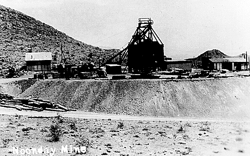
The above picture shows the Noonday mine a few miles East
of town. It was worked in the 1940's and lies on a faulted
offset of the same ore body that supported the Gunsight earlier
in the century and the War Eagle after World War II. Mines
I worked in include Gerstley Borax as (surveyor's helper),
Western Talc (miner) and War Eagle (miner) and Noonday, (power house operator, mechanic & electrician).
Those skills are still on my resume—seriously. While
working as a miner I lost much of my hearing, tinnitus, not
to mention a partner to a cave in at the Western Talc.
I left the War Eagle and
the Amargosa Country in 1951, never to return. I expected
to, but career opportunities diverted me from Geology into
Metallurgy and finally into Materials Science and industry
as engineer, researcher, lab manager, market developer, enterprise
founder and business owner. I still enjoy my trips back,
but they have stretched out in time after my brother died.
The Snake Room in Tecopa adjoined the general store. It
served two purposes: Bar and dance hall. Town meetings were
held in the grammar school. The Snake Room was famous for
its characters. Among them were Cross Country Mike, Short
Fuse Louie and the Black Swede.
Mike was famous for his method of getting from here to there.
Being a tramp miner and wino, he never owned a car. When
he couldn't hitch a ride, he would just take off and walk,
straight as a crow could fly, cross country. Mike was good
natured and stayed out of trouble.
Short fuse Louie, another tramp miner, got his moniker for
his habit of conserving fuse when blasting out a round—roughly
five to ten tons of ore. And true to life, he met his end
via a short fuse—leading to a half stick of dynamite—in
his mouth. Suicide is always tragic, but the early days on
the Amargosa had a suicide incidence far in excess of the
national average. Doubtless that was due in part to the bitter
and often-unstable people who tried to get away from it all by
fleeing to the isolation of the desert. But the desert does
not often comfort the disturbed personality. My bunk at the
Western Talc mine was Louie's the year before I moved in.
The Black Swede was quite another sort. Trouble often came
his way, because he knew how to handle it. My father was
constable and Deputy Sheriff for many years. When a warrant
came in for a real baddie on the lam from the big city cops
or the FBI, my father would deputize the Black Swede. Together
they made many an arrest. The Black Swede knew his way around
in fast company. The Tecopa jail was no place to be. A cage
of iron bars out in the open. My father had a big rail-road-car
lock on the door. No sanitary facility, not even a decent
bunk. Fortunately it was never occupied for long, only long
enough to cool off a temper or sober up.
|
|

Noonday Mine, a few miles East of Tecopa, looking East
at mid day. |
|
|
|
Zabriski > back
to top
Banks of Amargosa, opal to be found in valley sediments.
But don't go prospecting expecting to get rich. Gem quality
is not there, too small and too fractured. It is a great place for sunsets. |
|
No Picture |
|
|
|
Shoshone > back
to top
Oasis deluxe and swimming hole; an extinct and eroded volcano
lives near by.
The pool was six feet deep in the far end. Its water was
refreshed by a six inch pipe flowing continuously from the
largest natural spring in the region. View looks East.
Shoshone was another favorite spot to park. And this pool
was one reason. Another reason was that the Fourth of July
celebrations that always began a day early and stretched
a day late, no matter the day of the week. Still another
reason was the boarding house, my first memory of the restaurant
concept. It was not a true restaurant. When food was ready,
the cook clanged this big triangular "bell" and
the town came running. Roast beef, potatoes and dessert were
primary fare. I was always hungry.
Charlie Brown owned all of Shoshone and was like, rich and
famous—on the local scale. A general store, a gas station,
a home, a room or two for travelers, and the post office
were among his assets. His business included distributing
Standard Oil products and supplying diesel fuel and dynamite
to the local miners. But that never went to his head. Charlie
became a powerful State Senator, representing, not just Shoshone,
but the whole of Inyo County ably and well. Charlie was a
success story in another way. He never went past the third
grade. An inspiration? You bet!
Almost everyone loved Charlie. He never cheated anyone and
was forever doing something for someone. His few enemies
were mostly the ne'er-do-wells full of sour grapes. If a
tramp miner had an abscessed tooth, Charlie would pull it
with a big pair of pliers he kept for the purpose. Charlie
was a big man, well over six foot tall and well over 200
lbs. He had an unforgettable resonant voice pitched on the
tenor side. Kept a Model T in running order well into the
1960s.
Charlie arrived in Amargosa country not long after the turn
of the century. Word was that he bought the general store
in Greenwater and moved it to Shoshone. Greenwater was another
of those strikes (prospect really) that never panned out.
A few green stains (from copper) in the rocks here and there
was all there ever was. No shear zone to speak of, no rich
dike, no pegmatite, no hydrothermal mineralization or secondary
enrichment, not even any water!
Those were the days. Borax there was. And Borax was the
reason the T&T came into being. But Borax is another
story. See Death Valley Junction. |
|
 |
|
|
|
Gerstle > back
to top
Borax Mine, Ulexite/Colmanite mixture variety, just north
of Shoshone |
|
No Picture |
|
|
|
Evelyn > back
to top
Banks of Amargosa
"Nameless siding?" (North of Eagle Mountain)
Banks of Amargosa, pseudo playa lake.
Teal and mallard flocks would stop here on there annual
migrations. |
|
No Picture |
|
|
|
Death Valley Junction & Ash
Meadows > back to top
The caboose in the distance was used for sleeping.
The car in the foreground was the tool car.
Death Valley
was the "home office" of the T&T.
A Diesel powered mill for processing borax, then clay, was
the main sight to be seen in town. At its height, perhaps
30 families and a like number of single people made their
homes in Death Valley Junction. To me the big diesels were
the center of attention. The operators would always run me
off if they caught me, but I still managed to sneak peeks
to see how they were started, though it was years before
I understood the meaning of "compression ignition".
The Diesels also supplied electric power to the town and
to the round house where the T&T steam engines were repaired.
Imagine, kids living here had electric lights, and an out
house! My greatest wish as a young lad was to live in a "stuck
in house". And in summer, DVJ sported an ice-cold swimming
hole. It was, still is, so dry that the "wet bulb temperature ",
a fancy stand in for measuring humidity, could be in the
50-60F range when it was maybe 118F on the pool deck. The
pool water was always cold, straight from a deep well. The
balance between solar heating and evaporative cooling always
seemed to be on the wrong side for as soon as the waters
got warm enough to really enjoy a swim the algae arrived
and we had to drain and clean the pool. Cleaning the pool
was my first real job for real pay, summer of '41. Tony Castillo
and I split the fifty cents as I recall, for the all day
job.
Death Valley Junction had the most potential for social
activity in the early part of the century. But it was limited.
Being a company town, one had to "get permission" to
do certain things. Still there was a grammar school, post
office, general store, service station, motel, restaurant,
butcher shop, service station, depot, sewage processing building,
tennis court, town meeting hall (Korkill Hall)--now an "opera
house" operated by Madam Marta Becket, owner, choreographer,
and ticket taker, is
one of the few remaining citizens in town, and, oh yes, a fork in
the road to go with the mill dump. See NY Times, National Report, 14 Jan 2004, for more on the Becket story.
DVJ offered wondrous things for young lads to learn, not
to mention mischief to get into. The population was too coarse,
independent, and fluid to support a church. The only preacher
I remember who tried to change that, (1940), reserved Korkill
Hall and attracted only one scared little kid from a population
of 100 or so townsfolk. He soon gave up. |
|

The "OUTFIT" during switching operations in
Death Valley Junction. The "model" was likely my
older cousin on my father's side. |
|
|
|
Scranton > back
to top
Bentonite & other clays, site of Indian battles in the
folk lore. We rarely parked there. Rabbits and Big Horn sheep nearby could have made Scranton a staging area for hunts.
|
|
No Picture |
|
|
|
T&T Ranch > back
to top
Source of produce for Death Valley Junction—in the
earliest days, about a mile South of Leeland. |
|
No Picture |
|
|
|
Leeland > back
to top
Lee's Camp to West, Paiute Mesa, Nevada, to East
Lathrop
Wells Nev., lies two or three mile to the East and is the
terminus for California State Highway 127 which begins
at Baker and more or less parallels the T&T. From there
one has the option of going North to Beatty, South to Death
Valley Junction, or East to Las Vegas. Paiute Mesa, of nuclear-waste-storage
controversy fame, lies to the North East and was once accessible
from Lathrop Wells. The remains of an Indian encampment could
be found in the Mesa "high country." A natural
spring used to serve both the Paiute and Big Horn. Pinon
nuts were harvested by to locals until the Government took
over and closed the area off to public access.
Leeland had
a well and water tank like Rasor and was also a fun place
to park. It is in a sandy area, which was easy on our bare
feet. Shoes were only for school or winter. Two graves
lie just to the West of the T&T road bed. The
one I knew about was a suicide. His name died with my father
who buried him. Neither has a marker, just shallow depressions
observable during my last visit. To die in the desert, often
meant to lie alone for eternity.
|
|
No Picture |
|
|
|
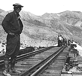
Carrera > back
to top
We never parked there in my memory, nor do I remember the
actual siding--each had its own special persomality. Still it was a "mile post". During
my time, there were 168 of them--Carerra being the first one in Nevada. And each mile post started
a new sequence of bridge numbers, like 98C, the third bridge
in that mile. Talk on the outfit was usually with respect
to 33A, 41B and so on. Each bridge had its own identifier
sign—big black letters on white. Carrera would have
been around mile post 158 or so. |
|
No Picture |
|
|
|
Beatty > back
to top
Oasis and silver and gold mines in nearby Ryolite
Beatty was the end of the line as I knew it. It was also
a lively town socially. Mining and ranching in the outlying
and isolated districts kept the town alive in the same manner
as Shoshone. It too was a fun place to park.
Beatty was also
a fork in the Tonopah to Las Vegas road. One fork led into
Death Valley via Rhyolite.
Like Baker, Shoshone, and Death Valley Junction, Beatty still supports
local service businesses, a church, mining activity, and
an outlying bawdy house. Beatty is about as close as one
can get to an old-West frontier town in the US.
|
|
No Picture |
| |
|
|
| |
|
|
| |
|
|
|
|
|